Hi there,
in this last post about my roadtrip on the US West coast, I will take you through 6 amazing national parks located in 3 different states Utah, Nevada and Arizona.
The first stop of the itinerary is the famous Grand Canyon in Arizona.
Maps of Grand Canyon:
https://www.nps.gov/grca/planyourvisit/maps.htm
It was carved by the Colorado River and has huge dimensions 277 miles long (446 kms) for an height up to 18 miles (29 kms).
For my visit, I choose to explore the South Rim. After having parked at the visitor center, I walk the few meters to the first viewpoint, the Mather Point. The view from there is simply amazing. The Canyon is so high that you can only feel very small and humble. The only times I felt so small (but not particularly humble) was when I went out in night clubs in Germany 🙂 After that, I keep on walking to the Yavapai Point to reach another very cool viewpoint. As there is a lot of tourists, some roads are closed to private cars and reserved for the park shuttle. So, I decide to jump in one and go the West side of the Park in the Hermit Rest area. As the bus drive is quite time consuming, I stop in the middle of the bus route at the Hopi point and walk till Powell Point. From those 2 points, the view on the Canyon is also amazing and the river Columbia can also be seen.


Back at the visitor center, I take the car to drive to the other side of the Park on the desert view road. I stop at Lipan and then Navajo point to enjoy a beautiful sunset on the Canyon.


After this nice day in Grand Canyon, my plan was to drive to Page to be close to the Antelope Canyon. However, as it’s already very late I stop in Tuba City for the night.
(daily miles 454, cumulated miles 3049)
On the next day, I wake up quite early to drive to the city Page. Just before I arrive in the city, I make a short stop at a cool place called the horse shoe Bend. This is a very scenic place, where the Colorado River makes a nice bend with blue and green colors. The trail going to the viewpoint is not long but it is steam hot outside. The viewpoint is quite impressive as we are free to go to the very edge of the cliff. As I fear height, I take my photos very quickly and stay a few meters from the edge 🙂


After a short breakfast in Page, I continue my route to the Antelope Canyon. This Canyon is divided in 2 parts, the lower and the upper Canyon and can be only visited by booking a tour. As I don’t know which one to visit, I stop at the first one on my road, which is the upper Canyon. Unfortunately there are already a lot of people in the parking lot, and so I can only book a place in the tour at 1pm, which is not optimal to take nice pictures. The sun is very high and so there’s a lot of light going inside. From the parking to the entrance of the Canyon, there’s a short drive in the desert with a 4WD. As there is a lot of visitors, we are not allowed to move freely and must follow a guide in groups of 10.
The Canyon is really impressive. The walls are made of layered curvy rocks that produce a very artistic atmosphere. As it’s already the afternoon, there’s a lot of light coming inside and it’s quite difficult to take correct nice picture. The camera sensors have difficulties to cope with the high contrast of the scene. However, taken at a correct angle, some shots are simply amazing.


The visit takes about 1,5 hours and after that I go back to Page to have a look at the impressive Glen Canyon Dam on the Colorado river.


To finish the day, I hit the road to my next destination, the Monument Valley park located on the Arizona-Utah border. Arrived at the camping where I’ll spend the night, I install my tent just in time to enjoy an amazing sunset on the world-famous Mitten and Merrick buttes.
(daily miles 203, cumulated miles 3252)


Map of Monument Valley:
http://www.navajonationparks.org/htm/monumentvalleydrive.htm
Monument Valley is one of the Navajo Tribal Parks. It is a huge desert where we can find so called monuments, which are in facts buttes and spire rocks structure.
There is only one small trail in the park where it’s possible to hike without a Navajo guide and so I decide to do the scenic drive.
I follow the unpaved road from one point of interest to another as described in the park brochure. The stops names triggers one’s imagination, some of them being some animals (camel, elephant). The views are beautiful, however the state of the road is really bad for the suspension of my cars.


After a couple of hours in Monument Valley, I stop a few minutes at the visitor center to buy some water and postcards and then cross the border to Utah to my next destination the Arches National Park.
Maps of Arches National Park:
https://www.nps.gov/arch/planyourvisit/maps.htm
Arches national park is located near the city of Moab and is very famous for its sandstone arches and towers.
As I arrive in the middle of the afternoon and the park is quite huge, I decide to divide the visit in two. On the first day, I drive on the lower part and first to the most famous arch, the Delicate Arch. As my time is a bit limited, I skip the main trail leading to the arch but hike on the 2 small trails below, which offered already nice views.


After that, I go back to the Windows section, where some mini trails lead to very nice arches, the most impressive one being the Double Arch. Further down on the road, I stop at an interesting viewpoint called the balanced rock, where a giant rock ball seems to have been put on the top of a spire structure.


Finally, my last stop of the day is the La Sal mountains viewpoint, where we can see, like the names indicates, the La Sal mountains in the background of the desert.


I spend the night in a nice little camping at the border of the Colorado river.
(daily miles 195, cumulated miles 3447)
On the next day, I decide to make a longer hike as I am a bit fed up spending so much time in the car. I go for the most difficult hike on the brochure, the trail to Dark Angel with the primitive trail portion (11,5 kms, 4-6 hours) in Devils’s garden. This hike is categorized as very difficult as it is sometimes very steep and the path is often on slippery rocks on the edge of cliffs. I arrive at the trailhead quite late, around 08:00, which is quite late but the outside temperature is still ok (28°). The first candy of the hike is the Landscape arch, a huge sandstone arch.


After that the difficult part starts. As the path is not very well indicated, I take the primitive trail, that I wanted to take only on the way back, instead of staying in the main trail. About 15m later, the path becomes unclear and I see footsteps in every direction. I choose to follow the path I think is the trail. I walk about 30mins and cross people going the opposite direction, which conforts me that I’m on the right way.


However 20mins after, the path disappears completely and the stones are going down very steep. I feel a bit confused but as the path is supposed to be the most difficult one of the park, I start to go down, well actually to slip down. After a few meters, I then have to crawl under some rocks, arrive at a wall and feel quite surprised. Where the f*** is the trail?? it can’t be here.


I start going down carefully but the path is then completely vertical (but the view on the valley is amazing). I stay a few minutes looking around to see if there’s a way but see absolutely none. After a while, I choose to go back. The problem is now, that the part where I slip down is now too steep and I cant go up! What am I gonna do? I’m blocked between the edge of a cliff and a mini wall that seems impossible to climb. I’ll spend about 1,5 hours trying different solutions. Finally, the solution was quite crazy. I saw some cracks on the mini wall, and put some stones to make a kind of stairs. Moreover I saw a pine tree with some resin on the trunk and used it to glue the stones on the wall and make my hands sticky to climb the wall. After several attempts, I finally succeeds to reach the top of the mini wall and go back to the trail where I came from. I was so scared to be stuck there that I need to seat 1 min to recover.
After that, I start walking back and meet some hikers a bit further. I ask them where is the primitive trail. They point me to a trail and I keep on walking.


The problem is that they pointed me to the wrong direction, so after 45 mins walking, I am actually back to the Landscape arch. The choice is now hard, I didn’t see anything in the devils garden but I am already a bit exhausted by the heat (43°). As always in this trip, I remind me that it may be the last time in my life that I am coming here and so I go back again on the trail. This time I luckily always stay on the trail and arrive at the Double O and the Dark Angel spire rock.

On the way back to the parking I also stop at 4 other small arches, the Navajo arch, the partition arch, and then the tunnel arch and the pine tree arch where I see some rabbits resting in the shadows.


This visit of this park was not very relaxed, but this parc is my favorite till now.
At the end of the afternoon, I drive to Cedar City in Utah, which will be my base to visit the last 2 parks, Bryce and Zion.
(daily miles 325, cumulated miles 3772)
Maps of Bryce Canyon national park:
https://www.nps.gov/brca/planyourvisit/maps.htm
Bryce Canyon is a national park famous for its collection of hoodoos (rock pillars) which are visible in amphitheaters along a 18 miles road.
I start my visit by going to the very end of the road at the rainbow point. The view on the hoodoos is very impressive. I then drive slowly back, stopping at the different viewpoints listed on the brochure.


Finally I stop at the sunset point to make a short hike down the Canyon, starting at Navajo trail (total about 3 miles, 5 kms). The atmosphere is fantastic and it’s very impressive to stand beside those giant red, white, orange rock pillars.
(daily miles 216, cumulated miles 3988)


I spend the next day at Zion national park.
Maps of Zion National Park:
https://www.nps.gov/zion/planyourvisit/maps.htm
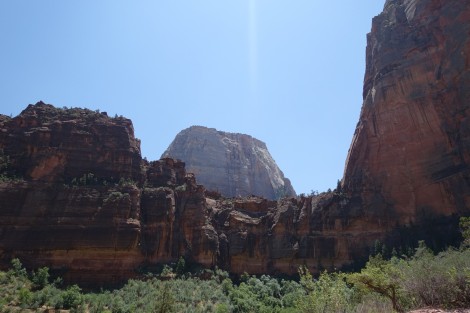
The park is divided in several parks. I chose to visit the most famous one, the Zion Canyon. I drive there around 10:00am. It is already really late and the parking lots at the entrance are already all full. The only remaining choice for me is to go back to the village just before and take the shuttle to explore the park. As it is really hot outside and it is quite slow to move by bus, I limit my visit to 3 stops. The first one is called The Big Bend and offers a nice view on the surrounding mountains.
 I then get off the bus at the “the Grotto” station to make the mini hike to Zion Lodge, the next bus stop. The trail goes along the river and offers really nice views on green landscapes.


Back at my car, I drive shortly to a nice trail located just above a tunnel called the Canyon Overview Trail. The trail is not so long but not so easy at the end of the day. The view on the canyon from the end of the trail is super cool.


It is now the end of the afternoon and I drive back to an intermediate stop on my way to Los Angeles where I’ll take the plane to Colombia. I choose the Luxor hotel in Las Vegas to recover a bit from my last days 🙂
(daily miles 235, cumulated miles 4223)
On the next day, I walk a bit on the Strip and ht the road for LA in the middle of the afternoon. The way is quite long as I am a bit tired and the driving is not so easy as the suspension of my cars are a bit destroyed due to the offroad drives in the parks during the last days. I arrive at my friend John’s place around 07:30pm to give the camping stuff back. I planned to stay there for the night and take the plane at 12:45pm. The problem is that when I check my ticket, I realise that the plane is not taking off at 12:45pm but 12:45 which in less then 4 hours. I am now a bit in a hurry as I need to give back my rental car before boarding the plane. I eat dinner very quickly and jump in the car. There’s a lot of traffic near the airport and instead of the 50mins estimated by Google maps, it takes me almost 2 hours. Luckily, it goes very fast at the car rental. According to my notes, the final kms of the road trip should be (daily miles 285, cumulated miles 4508). However, on the final bill the difference between the kms at the beginning and at the end (read on the car counter) is a bit higher and the total length of the trip is 5046 miles (8120 kms). I arrive with the shuttle bus to my terminal a few minutes before the end of the check in. The Delta airlines check in area is very good organised and I don’t queue more than 10 mins to drop off my luggage. As I walk to the gate, I am surprised that there’s no customs and immigration check. I suppose the airline is informing the authorities that I left the US territory.
At 12:30am I am boarding the plane that will bring me to Atlanta for a connection to Cartagena in Colombia.
Bye bye uncle Sam, it was a pleasure visiting you. I hope I’ll come visit you again soon. Latin America, here I come, put the beer in the fridge 🙂

Un remake de 230hours dans arches park….
LikeLike
J’y ai pense direct 🙂
LikeLike
Dieses Stück der Reise hat mich sehr begeistert weil immer wieder Teilelemente unseres West Coadt Trips dabei sind. Amazing!!!!!
LikeLiked by 1 person
Mon gars, tu t’es bien fait peur on dirait…
LikeLiked by 1 person